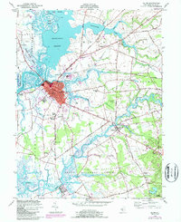
1948 Map of Salem
USGS Topo · Published 1987About this map
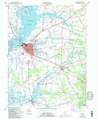
The Salem waterfront and its surrounding tidewater lowlands define this mid-century New Jersey landscape, where the Salem River meets a network of marshes and meadows. The area's agricultural and industrial character is evident in the dense street grid of the city, transitioning into the expansive Mannington Meadow and Abbotts Meadow. Inland, the map documents a transition from the busy urban center near Majors Wharf to outlying rural communities like Quinton and Hancocks Bridge.
Find a feature on this map
72 named features on this map. Tap any name to fly to it.
Don’t see what you’re looking for? This feature index may not catch every label — zoom into the map to look around manually.
Map Details
Editions of this 1948 Salem Map
5 editions found
Other maps of this area

1890 · Salem
USGS Topo · 1:62,500

1890 · Bay Side
USGS Topo · 1:62,500

1894 · Bay Side
USGS Topo · 1:62,500

1898 · Salem
USGS Topo · 1:62,500

1899 · Vineland
USGS Topo · 1:125,000

1899 · Dover
USGS Topo · 1:125,000

1901 · Camden
USGS Topo · 1:125,000

1904 · Wilmington
USGS Topo · 1:62,500

1906 · Dover
USGS Topo · 1:125,000

1906 · Wilmington
USGS Topo · 1:62,500
Featured Places
- Pennsville Township, NJ
- Salem, NJ
- Quinton Township, NJ
- Lower Alloways Creek Township, NJ
- Alloway Township, NJ