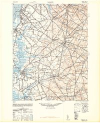
1948 Map of Salem
USGS Topo · Published 1948About this map
The Delaware River shoreline at Penns Grove and Carneys Point serves as the industrial gateway to this Salem County landscape. Moving inland, the terrain is defined by the winding courses of Oldmans Creek and the Salem River, which feed into a complex network of agricultural and milling communities. The post-war economy is reflected in the established rail lines of the Pennsylvania Reading Seashore Lines and the presence of utility infrastructure like the Transformer Station near Milltown.
Find a feature on this map
109 named features on this map. Tap any name to fly to it.
Don’t see what you’re looking for? This feature index may not catch every label — zoom into the map to look around manually.
Map Details
Editions of this 1948 Salem Map
3 editions found
Other maps of this area

1890 · Salem
USGS Topo · 1:62,500

1890 · Bay Side
USGS Topo · 1:62,500

1890 · Bridgeton
USGS Topo · 1:62,500

1890 · Glassboro
USGS Topo · 1:62,500

1891 · Philadelphia
USGS Topo · 1:62,500

1894 · Bay Side
USGS Topo · 1:62,500

1894 · Bridgeton
USGS Topo · 1:62,500

1894 · Chester
USGS Topo · 1:62,500

1894 · Philadelphia
USGS Topo · 1:62,500

1896 · Philadelphia
USGS Topo · 1:62,500