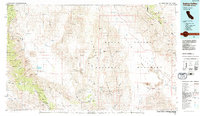
1985 Map of Saline Valley
USGS Topo · Published 1985About this map
The vast interior of Death Valley National Monument and the high peaks of the Panamint Range dominate this 1985 survey, showing a landscape defined by extreme topography and a history of hard-rock mining. The map captures the remote character of the Saline Valley and the Inyo Mountains, where deep canyons lead to scattered operations like the Lippincott Mine, Ubehebe Mine, and the Dolomite Quarries. This era of the desert landscape is marked by the presence of vital water sources in an arid environment, including Mesquite Spring, Hunter Spring, and the unpotable Badwater Sprs.
Find a feature on this map
99 named features on this map. Tap any name to fly to it.
Don’t see what you’re looking for? This feature index may not catch every label — zoom into the map to look around manually.
Map Details
Editions of this 1985 Saline Valley Map
2 editions found
Other maps of this area

1905 · Olancha
USGS Topo · 1:125,000

1907 · Olancha
USGS Topo · 1:125,000

1907 · Mt. Whitney
USGS Topo · 1:125,000

1908 · Kawich
USGS Topo · 1:250,000

1908 · Lida
USGS Topo · 1:250,000

1908 · Furnace Creek
USGS Topo · 1:250,000

1908 · Ballarat
USGS Topo · 1:250,000

1910 · Furnace Creek
USGS Topo · 1:250,000

1913 · Bishop
USGS Topo · 1:125,000

1913 · Lida
USGS Topo · 1:250,000