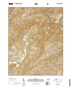
2019 Map of Salisbury
USGS Topo · Published 2019About this map
The James River winds along the northern edge of this Botetourt County landscape, shaping the development of settlements like Salisbury and Springwood. The area is defined by its ridge-and-valley topography, where the prominent Timber Ridge and Little Timber Ridge run parallel to waterways like Catawba Creek and Spreading Spring Br. This environment created natural corridors for early roads and farming, evidenced by the clustered settlements at Kyles Mills and Owens.
Find a feature on this map
75 named features on this map. Tap any name to fly to it.
Don’t see what you’re looking for? This feature index may not catch every label — zoom into the map to look around manually.
Map Details
Editions of this 2019 Salisbury Map
This is the sole edition of this map. No revisions or reprints were ever made.
Other maps of this area

1890 · Roanoke
USGS Topo · 1:125,000

1891 · Roanoke
USGS Topo · 1:125,000

1894 · Natural Bridge
USGS Topo · 1:125,000

1894 · Natural Bridge
USGS Topo · 1:62,500

1907 · Natural Bridge Special
USGS Topo · 1:62,500

1913 · Eagle Rock
USGS Topo · 1:48,000

1915 · Eagle Rock
USGS Topo · 1:62,500

1929 · Roanoke
USGS Topo · 1:48,000

1933 · Roanoke
USGS Topo · 1:62,500

1947 · Roanoke
USGS Topo · 1:250,000