1985 Map of Salisbury
USGS Topo · Published 1991About this map
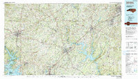
High Rock Lake and the Yadkin River corridor form the central axis of this Piedmont landscape, which documents the industrial and residential growth of the mid-1980s. The map captures the significant footprints of Salisbury, Statesville, and Kannapolis, showing the intersection of Interstate 85, Interstate 40, and Interstate 77 as they reshaped the region's transport patterns. Beyond the urban centers, the terrain transitions into the wooded ridges of the Uwharrie National Forest to the southeast, where peaks like High Rock Mtn and Flat Swamp Mtn rise above the reservoir system.
Find a feature on this map
138 named features on this map. Tap any name to fly to it.
Don’t see what you’re looking for? This feature index may not catch every label — zoom into the map to look around manually.
Map Details
Editions of this 1985 Salisbury Map
2 editions found

Other maps of this area

1889 · Wilkesboro
USGS Topo · 1:125,000

1891 · Wilkesboro
USGS Topo · 1:125,000

1891 · Yadkinville
USGS Topo · 1:125,000

1893 · Statesville
USGS Topo · 1:125,000

1893 · Yadkinville
USGS Topo · 1:125,000

1895 · Hickory
USGS Topo · 1:125,000

1914 · Gastonia
USGS Topo · 1:48,000

1916 · Gastonia
USGS Topo · 1:62,500

1941 · Charlotte
USGS Topo · 1:125,000

1942 · Troy
USGS Topo · 1:125,000