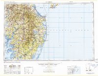
1947 Map of Salisbury
USGS Topo · Published 1948About this map
The Delmarva Peninsula is captured here just after World War II, revealing a landscape defined by its intricate shoreline and maritime defense infrastructure. This Army Map Service compilation details the strategic importance of the coast, noting the Fort Miles Military Reservation and the Cape May Naval Air Station flanking the entrance to the Delaware Bay. At the center of the Maryland eastern shore, Salisbury serves as a primary hub, while the coastal reaches show the early development of Ocean City and Rehoboth Beach long before the modern era of high-rise expansion. Navigation remains a primary theme, with distinct markings for the Brandywine Shoal Lighthouse and the Ocean City Seaplane Base. The map also traces the extensive rail network of the Pennsylvania railroad connecting agricultural centers like Seaford and Milford to the ports of the Atlantic Ocean.
Find a feature on this map
69 named features on this map. Tap any name to fly to it.
Don’t see what you’re looking for? This feature index may not catch every label — zoom into the map to look around manually.
Map Details
Editions of this 1947 Salisbury Map
This is the sole edition of this map. No revisions or reprints were ever made.
Other maps of this area

1884 · Sea Isle
USGS Topo · 1:62,500

1888 · Cape May
USGS Topo · 1:62,500

1888 · Dennisville
USGS Topo · 1:62,500

1888 · Sea Isle
USGS Topo · 1:62,500

1890 · Maurice Cove
USGS Topo · 1:62,500

1891 · Maurice Cove
USGS Topo · 1:62,500

1893 · Cape May
USGS Topo · 1:62,500

1894 · Dennisville
USGS Topo · 1:62,500

1894 · Sea Isle
USGS Topo · 1:62,500

1898 · Choptank
USGS Topo · 1:125,000