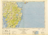
1948 Map of Salisbury
USGS Topo · Published 1951About this map
Salisbury serves as the central hub for the Delmarva Peninsula on this mid-century survey, which reveals a landscape deeply connected by rail and river. The Pennsylvania RR and Baltimore and Eastern RR lines intersect at major inland towns like Georgetown, Milford, and Seaford, anchoring a transit network that moved the region's agricultural and maritime goods. Along the Atlantic coast, the map details the early resort footprints of Ocean City and Rehoboth Beach, while prominent maritime landmarks like the Cape May Lighthouse and Fenwick Island Lighthouse signal the vital shipping lanes of the Delaware Bay.
Find a feature on this map
134 named features on this map. Tap any name to fly to it.
Don’t see what you’re looking for? This feature index may not catch every label — zoom into the map to look around manually.
Map Details
Editions of this 1948 Salisbury Map
This is the sole edition of this map. No revisions or reprints were ever made.
Other maps of this area

1884 · Sea Isle
USGS Topo · 1:62,500

1888 · Cape May
USGS Topo · 1:62,500

1888 · Dennisville
USGS Topo · 1:62,500

1888 · Sea Isle
USGS Topo · 1:62,500

1890 · Maurice Cove
USGS Topo · 1:62,500

1891 · Maurice Cove
USGS Topo · 1:62,500

1893 · Cape May
USGS Topo · 1:62,500

1894 · Dennisville
USGS Topo · 1:62,500

1894 · Sea Isle
USGS Topo · 1:62,500

1898 · Choptank
USGS Topo · 1:125,000