
1964 Map of Salix
USGS Topo · Published 1966About this map
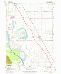
Salix serves as the primary hub of this Missouri River bottomland, anchored by the Chicago and North Western railroad corridor. The landscape is defined by the shifting course of the Missouri River, which forms the border between Iowa and Nebraska, and the prominent oxbow of Browns Lake. This area showcases the transition from riparian wetlands to a highly organized agricultural grid, evidenced by the extensive drainage systems like the Omaha Creek Ditch. Local genealogy is well-represented through multiple burial sites, including St Josephs Cem, Township Cem, and Walnut Grove Cem. To the southwest, the Winnebago Indian Reservation Boundary marks a significant cultural and political transition across the river, while Browns Lake State Park provides a dedicated recreational space near the water's edge. The infrastructure of the mid-1960s is clearly visible, from the Salix Interchange to the remote Landing Strip and Radio Towers.
Find a feature on this map
22 named features on this map. Tap any name to fly to it.
Don’t see what you’re looking for? This feature index may not catch every label — zoom into the map to look around manually.
Map Details
Editions of this 1964 Salix Map
2 editions found
Other maps of this area

1955 · Sioux City
USGS Topo · 1:250,000

1958 · Sioux City
USGS Topo · 1:250,000

1959 · Sioux City
USGS Topo · 1:250,000

1963 · Sioux City South
USGS Topo · 1:24,000

1964 · Sergeant Bluff
USGS Topo · 1:24,000

1964 · Lawton
USGS Topo · 1:24,000

1964 · Luton
USGS Topo · 1:24,000

1964 · Homer
USGS Topo · 1:24,000

1966 · Walthill
USGS Topo · 1:24,000

1969 · Albaton
USGS Topo · 1:24,000