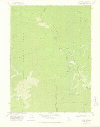
1978 Map of Salmon Mtn.
USGS Topo · Published 1978About this map
The Salmon Mountains define this high-elevation wilderness at the meeting point of Humboldt, Siskiyou, and Trinity Counties in the late 1970s. This landscape is a complex intersection of three major protected areas: Six Rivers National Forest, Klamath National Forest, and the Salmon Trinity Alps Primitive Area. Movement through this steep terrain is restricted to a network of historic paths such as the Pack Trail, Primitive Trail, and the Horse Prairie Jeep Trail.
Find a feature on this map
38 named features on this map. Tap any name to fly to it.
Don’t see what you’re looking for? This feature index may not catch every label — zoom into the map to look around manually.
Map Details
Editions of this 1978 Salmon Mtn. Map
2 editions found
Other maps of this area

1925 · Hoopa
USGS Topo · 1:125,000

1948 · Weed
USGS Topo · 1:250,000

1950 · Weed
USGS Topo · 1:250,000

1952 · Hoopa
USGS Topo · 1:62,500

1952 · Orleans
USGS Topo · 1:62,500

1955 · Salmon Mtn
USGS Topo · 1:62,500

1955 · Forks of Salmon
USGS Topo · 1:62,500

1958 · Weed
USGS Topo · 1:250,000

1963 · Weed
USGS Topo · 1:250,000

1974 · Orleans Mtn.
USGS Topo · 1:24,000