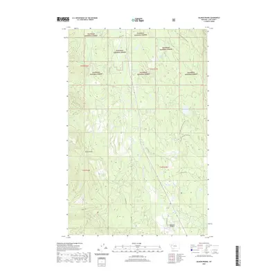
2020 Map of Salmon Prairie
USGS Topo · Published 2020About this map
Salmon Prairie serves as the focal point for this 2020 map, situated where Salmon Prairie Rd and Wise Rd meet in the valley bottom. The landscape is defined by the Swan River, which meanders northward through a series of significant riparian features including Simmons Meadow, Squeezer Meadow, and Woodward Meadows. The eastern slopes of the Mission Range dominate the western portion of the sheet, giving rise to numerous drainages such as Fatty Cr and Piper Cr.
Find a feature on this map
32 named features on this map. Tap any name to fly to it.
Don’t see what you’re looking for? This feature index may not catch every label — zoom into the map to look around manually.
Map Details
Editions of this 2020 Salmon Prairie Map
This is the sole edition of this map. No revisions or reprints were ever made.
Other maps of this area

1955 · Choteau
USGS Topo · 1:250,000

1957 · Choteau
USGS Topo · 1:250,000

1958 · Choteau
USGS Topo · 1:250,000

1962 · Choteau
USGS Topo · 1:250,000

1965 · Peck Lake
USGS Topo · 1:24,000

1965 · Condon
USGS Topo · 1:24,000
1965 · Thunderbolt Mountain
USGS Topo · 1:24,000

1965 · Swan Peak
USGS Topo · 1:24,000
1965 · Piper-Crow Pass
USGS Topo · 1:24,000
1965 · Cilly Creek
USGS Topo · 1:24,000