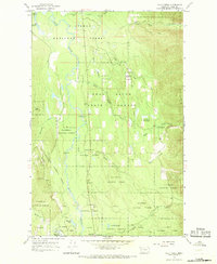
1965 Map of Cilly Creek
USGS Topo · Published 1968About this map
The Swan River meanders through a landscape defined by heavy forest management and recreational development during the mid-1960s. This survey illustrates the overlapping boundaries of the Flathead National Forest and the Swan River State Forest, highlighting a coordinated network of public land use. Notable infrastructure includes a Landing Strip and the State Forest Headquarters located south of Metcalf Lake, suggesting the area's importance as a base for aerial fire monitoring or timber operations. Remote accessibility is evident through the numerous designated camping spots, such as Point Pleasant Campground and Soup Creek Campground, alongside several miles of Pack Trail winding through the eastern highlands. Named features like Graves Meadows and Woodward Meadows break up the dense canopy, providing specific landmarks for early outdoor recreationists and surveyors.
Find a feature on this map
31 named features on this map. Tap any name to fly to it.
Don’t see what you’re looking for? This feature index may not catch every label — zoom into the map to look around manually.
Map Details
Editions of this 1965 Cilly Creek Map
2 editions found
Other maps of this area

1955 · Choteau
USGS Topo · 1:250,000

1957 · Choteau
USGS Topo · 1:250,000

1958 · Choteau
USGS Topo · 1:250,000

1962 · Choteau
USGS Topo · 1:250,000
1965 · Connor Creek
USGS Topo · 1:24,000
1965 · Swan Lake
USGS Topo · 1:24,000
1965 · Thunderbolt Mountain
USGS Topo · 1:24,000

1965 · Swan Peak
USGS Topo · 1:24,000
1965 · Yew Creek
USGS Topo · 1:24,000
1965 · Porcupine Creek
USGS Topo · 1:24,000