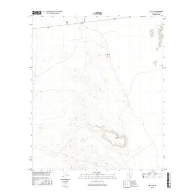
2016 Map of Salt Flat
USGS Topo · Published 2016About this map
Salt Flat sits in the high desert of Hudspeth County, where the stark topography of the Trans-Pecos meets a critical junction of desert travel. The map area is defined by the significant rise of Flattop Mtn and the prominence of Jim Hill, which overlook a landscape managed for water security in an arid environment. These scattered water resources, including Rock Tank, Cavender Tank, and Flattop Tank, indicate the essential infrastructure required for ranching and survival in this corner of West Texas. Connectivity is provided by the intersection of Ranch Rd 1576 and the main thoroughfare of 62 180, linking this isolated settlement to the wider region. The contour lines reveal the dramatic verticality of the terrain, illustrating the steep ridges and basins that characterize the land south of the namesake flats.
Find a feature on this map
8 named features on this map. Tap any name to fly to it.
Don’t see what you’re looking for? This feature index may not catch every label — zoom into the map to look around manually.
Map Details
Editions of this 2016 Salt Flat Map
This is the sole edition of this map. No revisions or reprints were ever made.
Other maps of this area

1933 · Guadalupe Peak
USGS Topo · 1:48,000

1940 · Guadalupe Peak
USGS Topo · 1:62,500

1951 · Dell City
USGS Topo · 1:62,500

1954 · Van Horn
USGS Topo · 1:250,000

1955 · Black Mountains
USGS Topo · 1:62,500

1958 · Van Horn
USGS Topo · 1:250,000

1973 · Bitter Well Mountain NW
USGS Topo · 1:24,000

1973 · Bitter Well Mountain SW
USGS Topo · 1:24,000
1973 · Patterson Hills
USGS Topo · 1:24,000
1984 · Babb Canyon
USGS Topo · 1:24,000