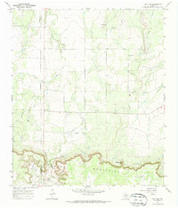
1967 Map of Salt Gap
USGS Topo · Published 1970About this map
The Brady Mountains rise sharply across the southern portion of this West Texas survey, creating a dramatic topographical transition from the high northern plains. Near the center of the sheet, the small settlement of Salt Gap sits at the intersection of local roads and cattle-country fence lines. The landscape is defined by its drainage patterns, with Salt Creek winding northward alongside Waloope Creek and Cottonwood Creek.
Find a feature on this map
13 named features on this map. Tap any name to fly to it.
Don’t see what you’re looking for? This feature index may not catch every label — zoom into the map to look around manually.
Map Details
Editions of this 1967 Salt Gap Map
2 editions found
Other maps of this area

1892 · Eden
USGS Topo · 1:125,000

1894 · Brady
USGS Topo · 1:125,000

1896 · Eden
USGS Topo · 1:125,000

1924 · Eden 1-a
USGS Topo · 1:48,000

1925 · Brady 2-b
USGS Topo · 1:48,000

1928 · Waldrip
USGS Topo · 1:62,500

1931 · Stacy
USGS Topo · 1:62,500

1954 · Brownwood
USGS Topo · 1:250,000

1960 · West Sweden
USGS Topo · 1:24,000

1960 · Melvin
USGS Topo · 1:24,000