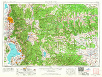
1954 Map of Salt Lake City
USGS Topo · Published 1967About this map
Salt Lake City and the expanding urban corridor along the western edge of the Wasatch Mountains anchor this mid-century topographic record. The map documents the post-war suburban growth of Murray, Midvale, and Orem as they bridged the gap between the state capital and Provo. This development is framed by the heavy industrial and institutional presence of the era, including the Fort Douglas Military Reservation and the State Mental Hospital near Utah Lake.
Find a feature on this map
206 named features on this map. Tap any name to fly to it.
Don’t see what you’re looking for? This feature index may not catch every label — zoom into the map to look around manually.
Map Details
Editions of this 1954 Salt Lake City Map
4 editions found

Other maps of this area

1885 · Salt Lake
USGS Topo · 1:250,000

1885 · Manti
USGS Topo · 1:250,000

1885 · East Tavaputs
USGS Topo · 1:250,000

1885 · Ashley
USGS Topo · 1:250,000

1885 · Sevier Desert
USGS Topo · 1:250,000

1885 · Uinta
USGS Topo · 1:250,000

1885 · Tooele Valley
USGS Topo · 1:250,000

1886 · Price River
USGS Topo · 1:250,000

1895 · Manti
USGS Topo · 1:250,000

1896 · Price River
USGS Topo · 1:250,000