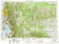
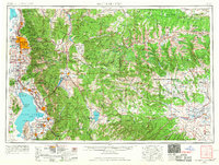
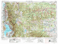
1954 Map of Salt Lake City
USGS Topo · Published 1973About this map
The Wasatch Mountains dominate the western edge of this mid-century landscape, creating a steep vertical barrier between the burgeoning urban corridor of the Jordan River valley and the high basins to the east. By the early 1950s, the metropolitan area from Salt Lake City south through Murray and Midvale to Provo shows a distinct pattern of settlement anchored by the Union Pacific and Denver and Rio Grande Western railroads.
Find a feature on this map
181 named features on this map. Tap any name to fly to it.
Don’t see what you’re looking for? This feature index may not catch every label — zoom into the map to look around manually.
Map Details
Editions of this 1954 Salt Lake City Map
4 editions found

Other maps of this area

1885 · Salt Lake
USGS Topo · 1:250,000

1885 · Manti
USGS Topo · 1:250,000

1885 · East Tavaputs
USGS Topo · 1:250,000

1885 · Ashley
USGS Topo · 1:250,000

1885 · Sevier Desert
USGS Topo · 1:250,000

1885 · Uinta
USGS Topo · 1:250,000

1885 · Tooele Valley
USGS Topo · 1:250,000

1886 · Price River
USGS Topo · 1:250,000

1895 · Manti
USGS Topo · 1:250,000

1896 · Price River
USGS Topo · 1:250,000