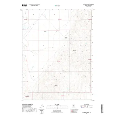
2018 Map of Salt Marsh Canyon
USGS Topo · Published 2018About this map
Simpson Park Mountains dominate the southern half of this Lander County landscape, where the high ridges give way to a network of drainage canyons and secluded water sources. The terrain is defined by its verticality, with deep cuts like Salt Marsh Canyon, Trail Canyon, and Grubbs Canyon funneling seasonal runoff toward the flat expanse of Grass Valley to the northwest. This area serves as a critical watershed for the region, marked by the presence of several named water points such as Cottonwood Spring, Allen Spring, and Liberty Springs. These small, reliable water sources were essential for the cattle ranching and transit that defined Central Nevada's interior. The map also traces the winding paths of Indian Cr and Callaghan Cr, illustrating how the desert hydrology dictates the layout of local land divisions and range use.
Find a feature on this map
22 named features on this map. Tap any name to fly to it.
Don’t see what you’re looking for? This feature index may not catch every label — zoom into the map to look around manually.
Map Details
Editions of this 2018 Salt Marsh Canyon Map
This is the sole edition of this map. No revisions or reprints were ever made.
Other maps of this area

1926 · Roberts Mountains
USGS Topo · 1:250,000

1929 · Roberts Mountains
USGS Topo · 1:250,000

1955 · Millett
USGS Topo · 1:250,000

1956 · Mount Callaghan
USGS Topo · 1:62,500

1956 · Walti Hot Springs
USGS Topo · 1:62,500

1956 · Hall Creek
USGS Topo · 1:62,500

1956 · Ackerman Canyon
USGS Topo · 1:62,500

1959 · Millett
USGS Topo · 1:250,000

1979 · Simpson Park Mtns
USGS Topo · 1:100,000
1986 · Fagin Mountain
USGS Topo · 1:24,000