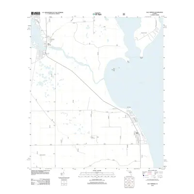
2012 Map of Salt Springs
USGS Topo · Published 2012About this map
Salt Springs serves as a central hub for outdoor recreation in this corner of Marion County, where the unique hydrology of the region is on full display. The waterway of Salt Springs Run flows eastward from the community toward the massive expanse of Lake George, passing Salt Springs Bar and Rocky Point. This 2012 survey illustrates a landscape defined by its interaction with water, from the shores of Lake Kerr in the west to the significant landmass of Drayton Island in the east. Local history and recreation are centered around sites like the Salt Springs Campground and Hopkins Campground, while the settlement of Yellow Bluff sits along the lakefront to the south. The road network, including NFR 86 and FR 10, provides access to these low-lying areas and isolated land features such as Hughes Island.
Find a feature on this map
31 named features on this map. Tap any name to fly to it.
Don’t see what you’re looking for? This feature index may not catch every label — zoom into the map to look around manually.
Map Details
Editions of this 2012 Salt Springs Map
This is the sole edition of this map. No revisions or reprints were ever made.
Other maps of this area

1954 · Daytona Beach
USGS Topo · 1:250,000

1958 · Daytona Beach
USGS Topo · 1:250,000

1964 · Daytona Beach
USGS Topo · 1:250,000

1970 · Crescent City
USGS Topo · 1:24,000

1970 · Welaka SE
USGS Topo · 1:24,000

1970 · Welaka
USGS Topo · 1:24,000
1970 · Lake Delancy
USGS Topo · 1:24,000

1970 · Salt Springs
USGS Topo · 1:24,000

1970 · Halfmoon Lake
USGS Topo · 1:24,000
1970 · Lake Kerr
USGS Topo · 1:24,000