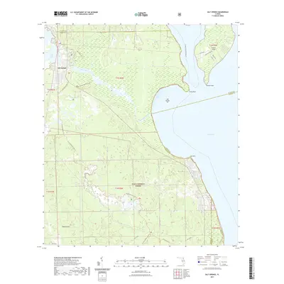
2021 Map of Salt Springs
USGS Topo · Published 2021About this map
Salt Springs serves as the focal point of this map, situated where the spring waters flow into the Salt Springs Run toward the expansive waters of Lake George. This landscape is defined by the dense vegetation of the Ocala National Forest, where intricate wetland systems like Bear Swamp and isolated upland areas such as Hughes Island dominate the terrain. The presence of Pats Island and various named trails suggests a long-standing relationship between the local geography and the recreational and historical paths that cross it.
Find a feature on this map
34 named features on this map. Tap any name to fly to it.
Don’t see what you’re looking for? This feature index may not catch every label — zoom into the map to look around manually.
Map Details
Editions of this 2021 Salt Springs Map
This is the sole edition of this map. No revisions or reprints were ever made.
Other maps of this area

1954 · Daytona Beach
USGS Topo · 1:250,000

1958 · Daytona Beach
USGS Topo · 1:250,000

1964 · Daytona Beach
USGS Topo · 1:250,000

1970 · Crescent City
USGS Topo · 1:24,000

1970 · Welaka SE
USGS Topo · 1:24,000

1970 · Welaka
USGS Topo · 1:24,000
1970 · Lake Delancy
USGS Topo · 1:24,000

1970 · Salt Springs
USGS Topo · 1:24,000

1970 · Halfmoon Lake
USGS Topo · 1:24,000
1970 · Lake Kerr
USGS Topo · 1:24,000