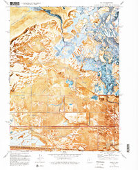
1972 Map of Saltair
USGS Topo · Published 1993About this map
Alkali flats and wetlands dominate this 1970s orthophotomosaic of the shoreline where the Great Salt Lake meets the desert. The landscape is defined by its complex hydraulic infrastructure, including the Consolidated Canal, Goggin Drain, and Surplus Canal, which manage water flow through this saline environment. Industrial activity is prominent along the southern edge, characterized by massive salt evaporators and a large tailings pond south of the Salt Lake Garfield and Western rail line. Sporting culture is well-documented through a series of named outposts like the Lake Front Duck Club and Rudy Duck Club, while landmarks like the KSL radio towers and the Terminal station anchor the survey's human geography. This map provides a rare visual of the transition from the Farmington Bay Waterfowl Management Area to the high-plains knolls such as Rabbit Knoll and Round Knoll.
Find a feature on this map
36 named features on this map. Tap any name to fly to it.
Don’t see what you’re looking for? This feature index may not catch every label — zoom into the map to look around manually.
Map Details
Editions of this 1972 Saltair Map
4 editions found
Other maps of this area

1885 · Salt Lake
USGS Topo · 1:250,000

1885 · Tooele Valley
USGS Topo · 1:250,000

1925 · Ft. Douglas
USGS Topo · 1:125,000

1928 · Ft. Douglas
USGS Topo · 1:125,000

1951 · Saltair
USGS Topo · 1:24,000

1951 · Salt Lake City South
USGS Topo · 1:24,000

1951 · Salt Lake City North
USGS Topo · 1:24,000

1952 · Saltair NE
USGS Topo · 1:24,000

1952 · Farmington
USGS Topo · 1:24,000

1952 · Magna
USGS Topo · 1:24,000