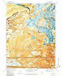
1972 Map of Saltair
USGS Topo · Published 1983About this map
Great Salt Lake dominates this landscape, showing the complex interaction of water and industry along the salt-crusted shores. This orthophotomap details a network of private hunting grounds such as the Lake Front Duck Club and Utah Duck Club interspersed with large-scale industrial operations. The southeastern portion is marked by the sprawling Salt Evaporators and the Tailings Pond, indicating the region's intensive mineral extraction history. Inland, an intricate system of water management is visible through features like the Goggin Drain, Consolidated Canal, and Brighton Drain. The area's transit and communication infrastructure is documented by the Salt Lake Garfield and Western railroad and the Radio Towers (KSL), while the iconic Saltair resort location sits near the transition from alkali flats to the open water.
Find a feature on this map
36 named features on this map. Tap any name to fly to it.
Don’t see what you’re looking for? This feature index may not catch every label — zoom into the map to look around manually.
Map Details
Editions of this 1972 Saltair Map
4 editions found
Other maps of this area

1885 · Salt Lake
USGS Topo · 1:250,000

1885 · Tooele Valley
USGS Topo · 1:250,000

1925 · Ft. Douglas
USGS Topo · 1:125,000

1928 · Ft. Douglas
USGS Topo · 1:125,000

1951 · Saltair
USGS Topo · 1:24,000

1951 · Salt Lake City South
USGS Topo · 1:24,000

1951 · Salt Lake City North
USGS Topo · 1:24,000

1952 · Saltair NE
USGS Topo · 1:24,000

1952 · Farmington
USGS Topo · 1:24,000

1952 · Magna
USGS Topo · 1:24,000