1955 Map of Salton Sea
USGS Topo · Published 1955About this map
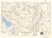
The Salton Sea dominates the southwestern portion of this map, its surface marked at 241 feet below sea level. This mid-century survey illustrates the intensive resource extraction and military/government presence in the arid basins of Southern California and western Arizona. Settlement is concentrated along the irrigation-fed Palo Verde Valley near Blythe and the southern reaches of the Salton Sink, where the Alamo River and New River flow through the agriculture-heavy Calipatria.
Find a feature on this map
151 named features on this map. Tap any name to fly to it.
Don’t see what you’re looking for? This feature index may not catch every label — zoom into the map to look around manually.
Map Details
Editions of this 1955 Salton Sea Map
2 editions found

Other maps of this area

1903 · Yuma
USGS Topo · 1:125,000

1904 · Indio
USGS Topo · 1:125,000

1905 · Yuma
USGS Topo · 1:125,000

1907 · Holtville
USGS Topo · 1:125,000

1911 · Parker
USGS Topo · 1:125,000

1915 · El Centro
USGS Topo · 1:125,000

1923 · Signal
USGS Topo · 1:250,000

1928 · Norton
USGS Topo · 1:62,500
1929 · Laguna
USGS Topo · 1:62,500

1929 · Norton
USGS Topo · 1:62,500