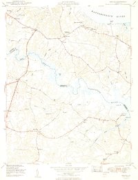
1949 Map of Saluda
USGS Topo · Published 1949About this map
Saluda serves as the focal point of this Tidewater landscape, situated between the tidal reaches of the Rappahannock River and the Piankatank River. In the late 1940s, the region was defined by a network of small agricultural and maritime settlements such as Stormont, Harcum, and Locust Hill. The map reveals a community deeply rooted in its local institutions, evidenced by the Middlesex Co Training School, Saluda High School, and historic religious sites like the Christ Church (PO) and Immanuel Church.
Find a feature on this map
59 named features on this map. Tap any name to fly to it.
Don’t see what you’re looking for? This feature index may not catch every label — zoom into the map to look around manually.
Map Details
Editions of this 1949 Saluda Map
2 editions found
Other maps of this area

1906 · Williamsburg
USGS Topo · 1:62,500

1916 · Kilmarnock
USGS Topo · 1:48,000

1916 · Mathews
USGS Topo · 1:62,500

1917 · Urbanna
USGS Topo · 1:62,500

1917 · Kilmarnock
USGS Topo · 1:62,500

1917 · Mathews
USGS Topo · 1:62,500

1942 · Kilmarnock
USGS Topo · 1:62,500

1943 · Richmond
USGS Topo · 1:250,000
1946 · Urbanna
USGS Topo · 1:24,000

1948 · Ware Neck
USGS Topo · 1:24,000