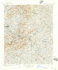
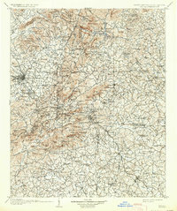
1907 Map of Saluda
USGS Topo · Published 1942About this map
Hendersonville and the surrounding mountain settlements are depicted here during the first years of the twentieth century, capturing the region's transition into a seasonal retreat and agricultural hub. The terrain is dominated by the steep ascent of the Blue Ridge, where the Southern railway line navigates the famous grade into Saluda. This era shows a landscape still defined by traditional crossings like Whiteside Ford and Dickie Ford, alongside early industrial sites such as Kemp Mill.
Find a feature on this map
163 named features on this map. Tap any name to fly to it.
Don’t see what you’re looking for? This feature index may not catch every label — zoom into the map to look around manually.
Map Details
Editions of this 1907 Saluda Map
3 editions found
Other maps of this area

1888 · Pickens
USGS Topo · 1:125,000

1894 · Asheville
USGS Topo · 1:125,000

1894 · Pickens
USGS Topo · 1:125,000

1900 · Mount Mitchell
USGS Topo · 1:125,000

1901 · Asheville
USGS Topo · 1:125,000

1902 · Mount Mitchell
USGS Topo · 1:125,000

1905 · Morganton
USGS Topo · 1:125,000

1905 · Pisgah
USGS Topo · 1:125,000

1906 · Pisgah
USGS Topo · 1:125,000

1907 · Saluda
USGS Topo · 1:125,000