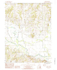
1984 Map of Sampsel
USGS Topo · Published 1985About this map
The Grand River meanders across the southern landscape of this Livingston County region, flanked by an extensive system of levee structures designed to manage the flood-prone bottomlands. This 1980s landscape shows the transition from the upland bluffs near Springhill down to the alluvial plains where Polecat Creek and Indian Creek join the main river system. The settlement pattern is defined by small clusters like Sampsel and Mooresville, which serve as anchors for the surrounding rural territory. North of the river, the terrain is deeply dissected by numerous waterways including Bachelor Branch and the interestingly named Penitentiary Branch. The presence of several unlabeled Cem sites and a prominent Quarry near the northern boundary suggests a long-standing local economy tied to both the land and its resources, while Shale Hill rises near Utica in the southeast corner.
Find a feature on this map
19 named features on this map. Tap any name to fly to it.
Don’t see what you’re looking for? This feature index may not catch every label — zoom into the map to look around manually.
Map Details
Editions of this 1984 Sampsel Map
This is the sole edition of this map. No revisions or reprints were ever made.
Other maps of this area

1921 · Chillicothe
USGS Topo · 1:62,500

1922 · Gallatin
USGS Topo · 1:62,500

1923 · Chillicothe
USGS Topo · 1:62,500

1924 · Dawn
USGS Topo · 1:62,500

1924 · Braymer
USGS Topo · 1:62,500

1951 · Utica
USGS Topo · 1:62,500

1953 · Moberly
USGS Topo · 1:250,000

1954 · Moberly
USGS Topo · 1:250,000

1957 · Moberly
USGS Topo · 1:250,000

1960 · Moberly
USGS Topo · 1:250,000