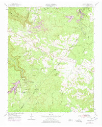
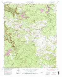
1954 Map of Sampson
USGS Topo · Published 1975About this map
Falls Creek Falls State Park dominates the southwestern quadrant of this Cumberland Plateau landscape, marking a transition from the level highlands into the deep incision of the Gulf. The terrain is defined by its dramatic hydrology, featuring the celebrated Falls Creek Falls and Cane Creek Falls. In the 1950s, the rural community structure was still well-defined by local landmarks such as Mt Della Ch, Mt View Ch, and the New Martin Sch. The settlement patterns at Sampson and Mooneyham reveal a reliance on the plateau's surface, while the deeper drainage of Cane Creek and its many tributaries like Rockhouse Creek carved out the inaccessible gorges. Smaller family footprints remain visible through the Walling Cem and DeBord Cem, alongside industrial traces like a Quarry and a Strip Mine that indicate the area's resource extraction history.
Find a feature on this map
52 named features on this map. Tap any name to fly to it.
Don’t see what you’re looking for? This feature index may not catch every label — zoom into the map to look around manually.
Map Details
Editions of this 1954 Sampson Map
5 editions found
Other maps of this area

1892 · Pikeville
USGS Topo · 1:125,000

1895 · Pikeville
USGS Topo · 1:125,000

1909 · Sequatchie Valley
USGS Topo · 1:62,500

1910 · Pikeville
USGS Topo · 1:62,500

1912 · Crossville
USGS Topo · 1:62,500

1935 · Brockdell
USGS Topo · 1:24,000

1935 · Billingsley Gap
USGS Topo · 1:24,000
1935 · Pikeville
USGS Topo · 1:24,000

1935 · Smart Mountain
USGS Topo · 1:24,000

1943 · Cookeville
USGS Topo · 1:100,000