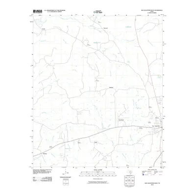
2010 Map of San Augustine West
USGS Topo · Published 2010About this map
San Augustine serves as the eastern anchor for this landscape, which is defined by its deep network of creeks and numerous family cemeteries. Small rural communities like Union, Redland, and Harmony are dispersed across the terrain, connected by a network of local roads that weave between water bodies such as Big Iron Ore Creek and Venado Creek. The abundance of burial sites, including Holt Cemetery, Greer Cemetery, and Thomas Cemetery, suggests a long-standing pattern of family land ownership and local settlement history throughout the county. In the southwest, Denning sits near the crossing of Niciper Creek, while the San Augustine County Airport provides modern infrastructure to the west of the town center. This area reflects a traditional East Texas settlement pattern where small hamlets emerged at crossroads and along the many branches of the local drainage system, such as Price Creek and Perkins Creek.
Find a feature on this map
33 named features on this map. Tap any name to fly to it.
Don’t see what you’re looking for? This feature index may not catch every label — zoom into the map to look around manually.
Map Details
Editions of this 2010 San Augustine West Map
This is the sole edition of this map. No revisions or reprints were ever made.
Other maps of this area

1953 · Palestine
USGS Topo · 1:250,000

1957 · Palestine
USGS Topo · 1:250,000

1958 · Broaddus
USGS Topo · 1:62,500

1958 · San Augustine
USGS Topo · 1:62,500

1958 · Martinsville
USGS Topo · 1:62,500

1958 · Bronson
USGS Topo · 1:62,500

1984 · Norwood
USGS Topo · 1:24,000
1984 · Chireno South
USGS Topo · 1:24,000
1984 · Chinquapin
USGS Topo · 1:24,000

1984 · Palestine
USGS Topo · 1:250,000