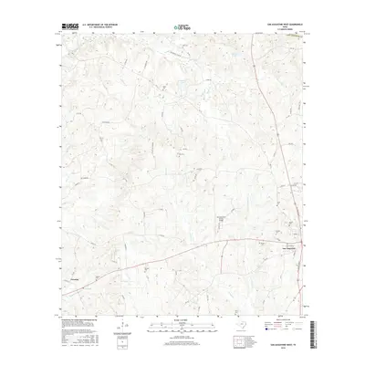
2016 Map of San Augustine West
USGS Topo · Published 2016About this map
The Piney Woods of Deep East Texas surround the western approaches to San Augustine, showing a landscape defined by an intricate network of creeks and small family cemeteries. This 2016 survey highlights the rural character of San Augustine County, where the land is carved by drainages such as Ayish Bayou, Venado Creek, and Perkins Creek. For genealogists, the map is a detailed record of local burials, documenting numerous sites including Holt Cemetery, Greer Cemetery, and Thomas Cemetery tucked away among the timber tracts and cattle ponds.
Find a feature on this map
78 named features on this map. Tap any name to fly to it.
Don’t see what you’re looking for? This feature index may not catch every label — zoom into the map to look around manually.
Map Details
Editions of this 2016 San Augustine West Map
This is the sole edition of this map. No revisions or reprints were ever made.
Other maps of this area

1953 · Palestine
USGS Topo · 1:250,000

1957 · Palestine
USGS Topo · 1:250,000

1958 · Broaddus
USGS Topo · 1:62,500

1958 · San Augustine
USGS Topo · 1:62,500

1958 · Martinsville
USGS Topo · 1:62,500

1958 · Bronson
USGS Topo · 1:62,500

1984 · Norwood
USGS Topo · 1:24,000
1984 · Chireno South
USGS Topo · 1:24,000
1984 · Chinquapin
USGS Topo · 1:24,000

1984 · Palestine
USGS Topo · 1:250,000