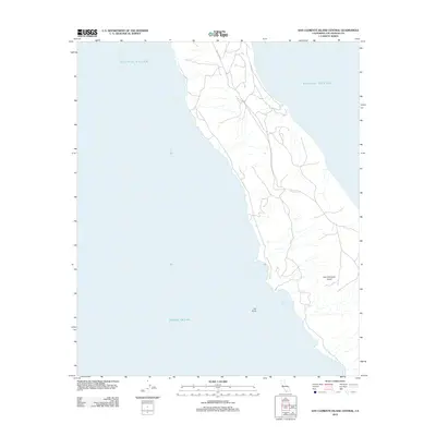
2012 Map of San Clemente Island Central
USGS Topo · Published 2012About this map
San Clemente Island presents a complex network of coastal roads and natural landforms along the central western shore of this California maritime territory. The map details the jagged coastline where the Pacific Ocean meets the island's terraced slopes, highlighting prominent coastal landmarks like Eel Point and the sheltered waters of Seal Cove. The interior is defined by a dense web of tracks and unimproved roads that traverse the island's high ridges, illustrating the logistical infrastructure required for this naval-managed landscape in the early 21st century. While the terrain is dominated by steep drainages and canyons, the absence of civilian settlements emphasizes the island's specialized status as a restricted military training range within Los Angeles County.
Find a feature on this map
4 named features on this map. Tap any name to fly to it.
Don’t see what you’re looking for? This feature index may not catch every label — zoom into the map to look around manually.
Map Details
Editions of this 2012 San Clemente Island Central Map
This is the sole edition of this map. No revisions or reprints were ever made.
Other maps of this area
1943 · San Clemente Island North
USGS Topo · 1:24,000

1943 · San Clemente Island Central
USGS Topo · 1:24,000

1949 · Long Beach
USGS Topo · 1:250,000
1950 · San Clemente Island North
USGS Topo · 1:24,000

1950 · San Clemente Island Central
USGS Topo · 1:24,000

1957 · Long Beach
USGS Topo · 1:250,000

1957 · San Clemente Island
USGS Topo · 1:250,000

1958 · Long Beach
USGS Topo · 1:250,000

1960 · Long Beach
USGS Topo · 1:250,000

1980 · San Clemente Island
USGS Topo · 1:100,000