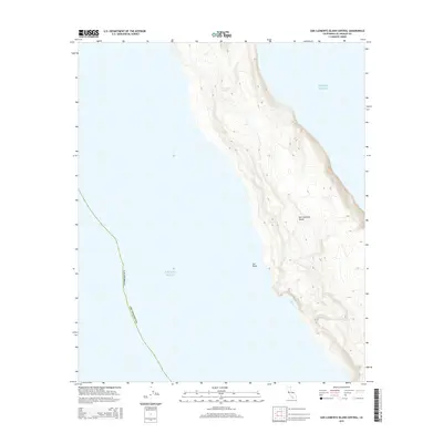
2015 Map of San Clemente Island Central
USGS Topo · Published 2015About this map
San Clemente Island rises from the Pacific Ocean in this 2015 topographic survey, revealing the high-relief contours of the island's central western coastline. The landscape is defined by its sheer coastal bluffs and narrow marine terraces, with prominent features like Eel Point and the sheltered waters of Seal Cove providing the only breaks in the primary coastal wall. While the interior remains largely undeveloped, the tight clustering of contour lines illustrates the rapid elevation gain from the sea to the island's central spine. This map captures the uninhabited and maritime character of this remote portion of Los Angeles County, where the terrain is shaped entirely by the elements of the open sea.
Find a feature on this map
5 named features on this map. Tap any name to fly to it.
Don’t see what you’re looking for? This feature index may not catch every label — zoom into the map to look around manually.
Map Details
Editions of this 2015 San Clemente Island Central Map
This is the sole edition of this map. No revisions or reprints were ever made.
Other maps of this area
1943 · San Clemente Island North
USGS Topo · 1:24,000

1943 · San Clemente Island Central
USGS Topo · 1:24,000

1949 · Long Beach
USGS Topo · 1:250,000
1950 · San Clemente Island North
USGS Topo · 1:24,000

1950 · San Clemente Island Central
USGS Topo · 1:24,000

1957 · Long Beach
USGS Topo · 1:250,000

1957 · San Clemente Island
USGS Topo · 1:250,000

1958 · Long Beach
USGS Topo · 1:250,000

1960 · Long Beach
USGS Topo · 1:250,000

1980 · San Clemente Island
USGS Topo · 1:100,000