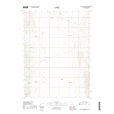
2018 Map of San Emidio Desert North
USGS Topo · Published 2018About this map
The Fox Range dominates the western portion of this Great Basin landscape, where high ridgelines give way to the sprawling basins of the Black Rock Desert to the north and the San Emidio Desert to the south. This area of Washoe County is characterized by seasonal drainages and remote ranching infrastructure, connected by routes like Farm District Rd and Empire Ranch Rd. Water sources are critical but scarce in this arid environment, marked by features such as Jackass Spring and the ephemeral flows of Willow Cr and Rodeo Cr. Significant geological features define the southern terrain, notably the deep cuts of Rattlesnake Canyon and Little Rattlesnake Canyon. This survey illustrates the sparse, functional road network and traditional land divisions that have long supported cattle ranching and open-range land use in Nevada.
Find a feature on this map
19 named features on this map. Tap any name to fly to it.
Don’t see what you’re looking for? This feature index may not catch every label — zoom into the map to look around manually.
Map Details
Editions of this 2018 San Emidio Desert North Map
This is the sole edition of this map. No revisions or reprints were ever made.
Other maps of this area

1886 · Granite Range
USGS Topo · 1:250,000

1894 · Granite Range
USGS Topo · 1:250,000

1955 · Lovelock
USGS Topo · 1:250,000

1959 · Lovelock
USGS Topo · 1:250,000

1964 · Gerlach
USGS Topo · 1:62,500

1964 · Kumiva Peak
USGS Topo · 1:62,500

1965 · Fox Range
USGS Topo · 1:62,500

1980 · Smith Canyon
USGS Topo · 1:24,000

1981 · Gerlach
USGS Topo · 1:100,000
1984 · Kumiva Peak
USGS Topo · 1:100,000