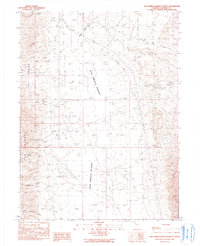
1990 Map of San Emidio Desert North
USGS Topo · Published 1990About this map
The San Emidio Desert and the eastern slopes of the Fox Range define this high-desert region of Washoe County during the late twentieth century. This transition between desert basins and upland peaks is marked by a series of seasonal drainages, including Willow Creek, Coyote Creek, and Bull Basin Creek, which descend toward the arid flats. The map illustrates a landscape of extreme isolation, where human presence is indicated primarily by a Steel Tower Trans Line and a single Borrow Pit, emphasizing the area's remote character.
Find a feature on this map
14 named features on this map. Tap any name to fly to it.
Don’t see what you’re looking for? This feature index may not catch every label — zoom into the map to look around manually.
Map Details
Editions of this 1990 San Emidio Desert North Map
This is the sole edition of this map. No revisions or reprints were ever made.
Other maps of this area

1886 · Granite Range
USGS Topo · 1:250,000

1894 · Granite Range
USGS Topo · 1:250,000

1955 · Lovelock
USGS Topo · 1:250,000

1959 · Lovelock
USGS Topo · 1:250,000

1964 · Gerlach
USGS Topo · 1:62,500

1964 · Kumiva Peak
USGS Topo · 1:62,500

1965 · Fox Range
USGS Topo · 1:62,500

1980 · Smith Canyon
USGS Topo · 1:24,000

1981 · Gerlach
USGS Topo · 1:100,000
1984 · Kumiva Peak
USGS Topo · 1:100,000