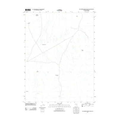
2011 Map of San Emidio Desert South
USGS Topo · Published 2011About this map
San Emidio Spring and Boiling Spring emerge from the arid basin of northern Nevada, defining a landscape shaped by intermittent water and dramatic elevation changes. This 2011 survey illustrates the high desert geography of Washoe County, where the expansive White Sage Flat sits between prominent landforms like Wildcat Peak and Kits Peak. The map details a complex system of drainages, including San Emidio Canyon and Stag Canyon, which funnel seasonal runoff toward the valley floor. Sparse roads cross the terrain, reflecting the area's contemporary state as an open, unpopulated range where water sources like Stag Spring remain critical landmarks for navigation and local land use.
Find a feature on this map
10 named features on this map. Tap any name to fly to it.
Don’t see what you’re looking for? This feature index may not catch every label — zoom into the map to look around manually.
Map Details
Editions of this 2011 San Emidio Desert South Map
This is the sole edition of this map. No revisions or reprints were ever made.
Other maps of this area

1886 · Granite Range
USGS Topo · 1:250,000

1894 · Granite Range
USGS Topo · 1:250,000

1955 · Lovelock
USGS Topo · 1:250,000

1959 · Lovelock
USGS Topo · 1:250,000
1964 · Tohakum Peak NE
USGS Topo · 1:24,000

1964 · Tohakum Peak NW
USGS Topo · 1:24,000

1964 · Kumiva Peak
USGS Topo · 1:62,500

1964 · Pyramid NE
USGS Topo · 1:24,000

1965 · Fox Range
USGS Topo · 1:62,500
1984 · Kumiva Peak
USGS Topo · 1:100,000