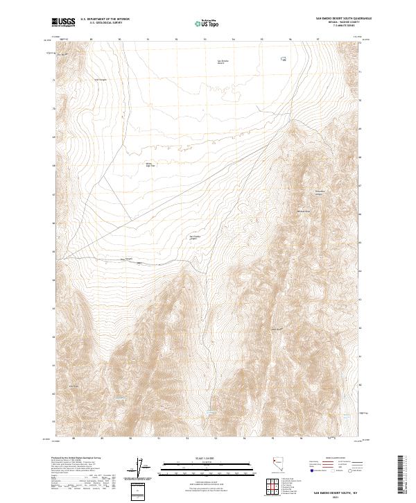
2021 Map of San Emidio Desert South
USGS Topo · Published 2021About this map
The San Emidio Desert and the eastern flanks of the Fox Range dominate this corner of Washoe County. This landscape is defined by its extreme relief and scarce water sources, as the terrain drops from high points like Wildcat Peak and Kits Peak down into the expansive White Sage Flat. The mapping reveals a network of drainage features including San Emidio Canyon, Stag Canyon, and Threemile Canyon that cut through the north-south trending ridges of the Lake Range. The presence of Stag Spring, San Emidio Spring, and the geothermal Boiling Spring at the southern edge of the desert basin highlights the vital, if rare, water points essential for life and travel in this arid environment. The map provides a detailed view of the public land survey system lines, marking the intersection of T29N and T28N across the desert floor and mountain slopes.
Find a feature on this map
18 named features on this map. Tap any name to fly to it.
Don’t see what you’re looking for? This feature index may not catch every label — zoom into the map to look around manually.
Map Details
Editions of this 2021 San Emidio Desert South Map
This is the sole edition of this map. No revisions or reprints were ever made.
Other maps of this area

1886 · Granite Range
USGS Topo · 1:250,000

1894 · Granite Range
USGS Topo · 1:250,000

1955 · Lovelock
USGS Topo · 1:250,000

1959 · Lovelock
USGS Topo · 1:250,000
1964 · Tohakum Peak NE
USGS Topo · 1:24,000

1964 · Tohakum Peak NW
USGS Topo · 1:24,000

1964 · Kumiva Peak
USGS Topo · 1:62,500

1964 · Pyramid NE
USGS Topo · 1:24,000

1965 · Fox Range
USGS Topo · 1:62,500
1984 · Kumiva Peak
USGS Topo · 1:100,000