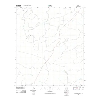
2010 Map of San Esteban Lake SW
USGS Topo · Published 2010About this map
Perdiz Creek and Shannon Draw define the drainage patterns of this high desert landscape in Presidio County. The terrain is deeply inscribed by ephemeral watercourses like Stage Stand Draw and Dunman Creek, which funnel seasonal runoff toward the south and east. A long-standing transportation corridor is represented by Route 67, cutting a diagonal path through the arid landscape and connecting the region's isolated outposts. Outside of this primary road, the map reveals a sparsely developed territory where natural landmarks and family-named features like Matonoso Creek provide the primary points of orientation. A single Oil Well serves as a small marker of human industry amidst the vast network of draws and creeks including Cienega Creek, illustrating the intersection of natural topography and local resource exploration in the early 21st century.
Find a feature on this map
8 named features on this map. Tap any name to fly to it.
Don’t see what you’re looking for? This feature index may not catch every label — zoom into the map to look around manually.
Map Details
Editions of this 2010 San Esteban Lake SW Map
This is the sole edition of this map. No revisions or reprints were ever made.
Other maps of this area

1895 · Marfa
USGS Topo · 1:125,000

1896 · Shafter
USGS Topo · 1:125,000

1959 · Presidio
USGS Topo · 1:250,000

1959 · Marfa
USGS Topo · 1:250,000

1965 · Presidio
USGS Topo · 1:250,000

1965 · Marfa
USGS Topo · 1:250,000
1983 · San Esteban Lake
USGS Topo · 1:24,000

1983 · Cuesta Del Burro East
USGS Topo · 1:24,000
1983 · Frenchman Hills
USGS Topo · 1:24,000
1983 · Cerros Prietos
USGS Topo · 1:24,000