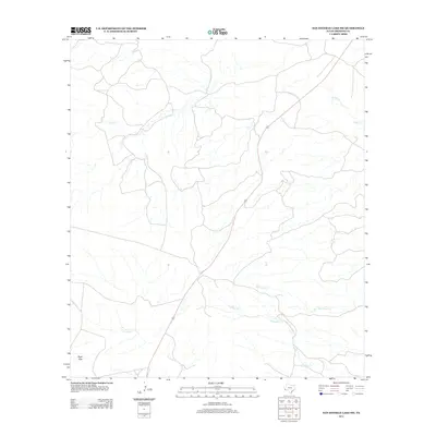
2012 Map of San Esteban Lake SW
USGS Topo · Published 2012About this map
Perdiz Cr and its tributaries define the drainage patterns of this high-desert landscape in Presidio County, as captured in this 2012 survey. The area is characterized by ephemeral watercourses and isolated terrain features like the Black Hills in the southwest corner. Transportation in the region is anchored by a primary north-south route that cuts through the center of the sheet, crossing several arroyos including Cienega Cr, Dunman Cr, and Matonoso Cr. These creek systems represent vital landmarks in an otherwise sparse ranching environment, offering a look at the natural boundaries and water access points that have historically dictated land use and travel routes through this portion of the Texas Big Bend region.
Find a feature on this map
5 named features on this map. Tap any name to fly to it.
Don’t see what you’re looking for? This feature index may not catch every label — zoom into the map to look around manually.
Map Details
Editions of this 2012 San Esteban Lake SW Map
This is the sole edition of this map. No revisions or reprints were ever made.
Other maps of this area

1895 · Marfa
USGS Topo · 1:125,000

1896 · Shafter
USGS Topo · 1:125,000

1959 · Presidio
USGS Topo · 1:250,000

1959 · Marfa
USGS Topo · 1:250,000

1965 · Presidio
USGS Topo · 1:250,000

1965 · Marfa
USGS Topo · 1:250,000
1983 · San Esteban Lake
USGS Topo · 1:24,000

1983 · Cuesta Del Burro East
USGS Topo · 1:24,000
1983 · Frenchman Hills
USGS Topo · 1:24,000
1983 · Cerros Prietos
USGS Topo · 1:24,000