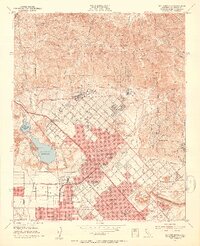
1953 Map of San Fernando
USGS Topo · Published 1954About this map
The San Fernando Mission and its adjacent San Fernando Mission Cem anchor the historic core of this region as it appeared in the early 1950s. The landscape is defined by the sharp transition between the residential blocks of San Fernando, Sylmar, and Pacoima and the steep front of the San Gabriel Mountains. This era shows a significant infrastructure of care and water management, featuring the Olive View Sanatorium, the U S Veteran Hospital, and the I O F Sanatorium tucked against the hillsides. Large-scale water engineering is evident through the San Fernando Reservoir, Pacoima Dam, and the Hansen Flood Control Basin. Aviation history is represented by the Whiteman Air Park and San Fernando Airport, while the Southern Pacific tracks and San Fernando Road indicate the primary transportation corridors of the mid-century valley.
Find a feature on this map
70 named features on this map. Tap any name to fly to it.
Don’t see what you’re looking for? This feature index may not catch every label — zoom into the map to look around manually.
Map Details
Editions of this 1953 San Fernando Map
3 editions found

Other maps of this area

1894 · Los Angeles
USGS Topo · 1:62,500

1896 · Santa Monica
USGS Topo · 1:62,500

1898 · Santa Monica
USGS Topo · 1:62,500

1900 · Los Angeles
USGS Topo · 1:62,500

1900 · Fernando
USGS Topo · 1:62,500

1901 · Southern California Sheet No. 1
USGS Topo · 1:250,000

1902 · Santa Monica
USGS Topo · 1:62,500

1903 · Calabasas
USGS Topo · 1:62,500

1903 · Camulos
USGS Topo · 1:125,000

1903 · Santa Susana
USGS Topo · 1:62,500