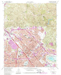
1966 Map of San Fernando
USGS Topo · Published 1988About this map
Mission San Fernando serves as the cultural anchor of this mid-century valley landscape, surrounded by the suburban expansion of San Fernando, Pacoima, and Mission Hills. The map details a period of rapid infrastructure growth, where the Golden State Freeway and San Diego Freeway carve through established neighborhoods and rugged canyon approaches. Significant civic and religious institutions are prominent, including the San Fernando Mission Cemetery, Pioneer Memorial Cem, and the Seminary of our Lady Queen of the Angels. Water management is a defining theme, visible in the massive engineering of Upper Van Norman Lake and the Hansen Dam Park flood control basin. The northern edge transitions sharply into the Angeles National Forest, where steep terrain like Kagel Mountain and Sugarloaf rises above the urban grid, separated by firebreaks and canyons.
Find a feature on this map
66 named features on this map. Tap any name to fly to it.
Don’t see what you’re looking for? This feature index may not catch every label — zoom into the map to look around manually.
Map Details
Editions of this 1966 San Fernando Map
3 editions found
Other maps of this area

1894 · Los Angeles
USGS Topo · 1:62,500

1896 · Santa Monica
USGS Topo · 1:62,500

1898 · Santa Monica
USGS Topo · 1:62,500

1900 · Los Angeles
USGS Topo · 1:62,500

1900 · Fernando
USGS Topo · 1:62,500

1901 · Southern California Sheet No. 1
USGS Topo · 1:250,000

1902 · Santa Monica
USGS Topo · 1:62,500

1903 · Calabasas
USGS Topo · 1:62,500

1903 · Camulos
USGS Topo · 1:125,000

1903 · Santa Susana
USGS Topo · 1:62,500