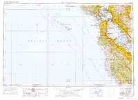
1956 Map of San Francisco
USGS Topo · Published 1976About this map
San Francisco and its surrounding Bay Area communities appear here in a period of significant post-war expansion. The map details the complex military and maritime infrastructure of the era, from the Presidio and Treasure Island Naval Station to the industrial presence of the Hunters Point Naval Shipyard. This 1950s-era geography captures the region as the modern suburban landscape took shape, including the growth of the Peninsula through Burlingame, San Mateo, and the academic grounds of Stanford University.
Find a feature on this map
314 named features on this map. Tap any name to fly to it.
Don’t see what you’re looking for? This feature index may not catch every label — zoom into the map to look around manually.
Map Details
Editions of this 1956 San Francisco Map
4 editions found

Other maps of this area

1889 · San Jose
USGS Topo · 1:62,500

1892 · San Mateo
USGS Topo · 1:62,500

1895 · San Francisco
USGS Topo · 1:62,500

1896 · San Mateo
USGS Topo · 1:62,500

1896 · Carquinez Strait
USGS Topo · 1:62,500

1896 · Mt. Diablo
USGS Topo · 1:62,500

1897 · San Jose
USGS Topo · 1:62,500

1897 · Concord
USGS Topo · 1:62,500

1897 · Palo Alto
USGS Topo · 1:62,500

1897 · Tamalpais
USGS Topo · 1:62,500