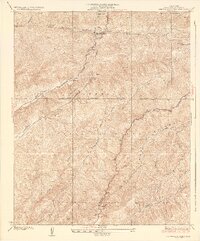
1937 Map of San Francisquito
USGS Topo · Published 1937About this map
San Francisquito Power House No 1 and its accompanying Surge Tank anchor the industrial infrastructure of this mountainous region during the 1930s. This survey, conducted just years after the devastating 1928 dam collapse in the same canyon, captures a landscape defined by water management and power generation for the growing Southern California metropolis. The Los Angeles Transmission Line cuts across the Sierra Pelona range, marking the vital energy corridor through the Angeles National Forest. In the northeast, the Bouquet Reservoir appears as a significant water storage feature, while the presence of Camp 2 along the Bouquet Canyon road suggests localized activity related to forest management or utility maintenance. Numerous steep drainages, such as Clearwater Canyon and Texas Canyon, carve the terrain between Jupiter Mountain and the surrounding peaks.
Find a feature on this map
23 named features on this map. Tap any name to fly to it.
Don’t see what you’re looking for? This feature index may not catch every label — zoom into the map to look around manually.
Map Details
Editions of this 1937 San Francisquito Map
4 editions found
Other maps of this area

1900 · Fernando
USGS Topo · 1:62,500

1901 · Southern California Sheet No. 1
USGS Topo · 1:250,000

1903 · Tejon
USGS Topo · 1:125,000

1903 · Camulos
USGS Topo · 1:125,000

1903 · Santa Susana
USGS Topo · 1:62,500

1904 · Southern California Sheet No. 1
USGS Topo · 1:250,000

1915 · Elizabeth Lake
USGS Topo · 1:125,000

1917 · Elizabeth Lake
USGS Topo · 1:125,000

1929 · Saugus
USGS Topo · 1:24,000

1929 · Lang
USGS Topo · 1:24,000