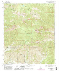
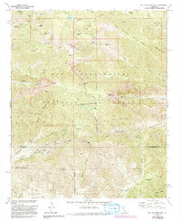
1970 Map of San Gorgonio Mtn
USGS Topo · Published 1994About this map
San Gorgonio Mtn dominates this high-altitude landscape within the San Bernardino National Forest, where steep canyons and alpine ridges create a complex drainage network for the Whitewater River and Mill Creek. The map documents the intersection of wilderness and early infrastructure, including the Banning San Gorgonio Flume and a Powerhouse near Big Oaks. These water-management features, alongside the Mill Creek Mine (Quarry), illustrate the industrial utility of the mountains for the surrounding valley communities. Small mountain outposts like South Fork Cabins and East Fork Cabin are nestled near the San Gorgonio Wilderness boundary, while the southern reaches of the map descend toward the Morongo Indian Reservation at Burro Flats. The presence of many named springs and flats, such as Lodgepole Spring and Raywood Flat, highlights the critical water sources that once sustained seasonal mountain camps and early forest management.
Find a feature on this map
103 named features on this map. Tap any name to fly to it.
Don’t see what you’re looking for? This feature index may not catch every label — zoom into the map to look around manually.
Map Details
Editions of this 1970 San Gorgonio Mtn Map
5 editions found
Other maps of this area

1901 · Southern California Sheet No. 1
USGS Topo · 1:250,000

1901 · San Jacinto
USGS Topo · 1:125,000

1902 · San Gorgonio
USGS Topo · 1:125,000

1904 · Southern California Sheet No. 1
USGS Topo · 1:250,000

1940 · Palm Springs
USGS Topo · 1:62,500

1942 · Banning
USGS Topo · 1:62,500

1943 · Banning
USGS Topo · 1:62,500

1944 · Palm Springs
USGS Topo · 1:62,500

1947 · Santa Ana
USGS Topo · 1:250,000

1949 · Santa Ana
USGS Topo · 1:250,000