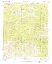
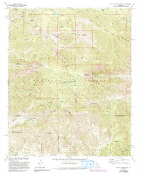
1970 Map of San Gorgonio Mtn
USGS Topo · Published 1975About this map
San Gorgonio Mtn dominates this high-altitude landscape, anchoring the northern reaches of the San Gorgonio Wilderness. The map reveals a complex network of hydrological and industrial features, including the Penstock Powerhouse and a Diversion Dam on the South Fork Whitewater River. To the south, the Morongo Indian Reservation spans the foothills near Burro Flats, while the north is defined by prominent peaks like Jepson Peak and Grinnell Mtn. Evidence of early resource management and recreation is visible through labels like the Mill Creek Mine (Quarry), South Fork Cabin, and several remote mountain springs. The convergence of the San Bernardino Co and Riverside Co line cuts through the southern canyons, where the Whitewater River and Banning River systems originate. This survey details the transition from the alpine ridges of Ten Thousand Foot Ridge to the alluvial flats and canyons of the southern forest boundary.
Find a feature on this map
63 named features on this map. Tap any name to fly to it.
Don’t see what you’re looking for? This feature index may not catch every label — zoom into the map to look around manually.
Map Details
Editions of this 1970 San Gorgonio Mtn Map
5 editions found
Other maps of this area

1901 · Southern California Sheet No. 1
USGS Topo · 1:250,000

1901 · San Jacinto
USGS Topo · 1:125,000

1902 · San Gorgonio
USGS Topo · 1:125,000

1904 · Southern California Sheet No. 1
USGS Topo · 1:250,000

1940 · Palm Springs
USGS Topo · 1:62,500

1942 · Banning
USGS Topo · 1:62,500

1943 · Banning
USGS Topo · 1:62,500

1944 · Palm Springs
USGS Topo · 1:62,500

1947 · Santa Ana
USGS Topo · 1:250,000

1949 · Santa Ana
USGS Topo · 1:250,000