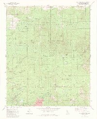
1981 Map of San Jacinto Peak
USGS Topo · Published 1984About this map
San Jacinto Peak towers over a landscape defined by dramatic elevation changes and protected wilderness areas in this early 1980s survey. The map centers on the high-altitude terrain of the San Jacinto State Park and San Jacinto Wilderness, showing a dense network of alpine trails including the Pacific Crest National Scenic Trail and the Skyline Trail. The transition from the rugged peaks of Cornell Peak and Jean Peak down to the mountain communities of Idyllwild and Pine Cove in the southwest corner illustrates the area's development as a retreat for hiking and mountaineering.
Find a feature on this map
96 named features on this map. Tap any name to fly to it.
Don’t see what you’re looking for? This feature index may not catch every label — zoom into the map to look around manually.
Map Details
Editions of this 1981 San Jacinto Peak Map
3 editions found
Other maps of this area

1901 · Southern California Sheet No. 1
USGS Topo · 1:250,000

1901 · San Jacinto
USGS Topo · 1:125,000

1904 · Southern California Sheet No. 1
USGS Topo · 1:250,000

1940 · Palm Springs
USGS Topo · 1:62,500

1940 · Hemet Reservoir
USGS Topo · 1:62,500

1942 · Banning
USGS Topo · 1:62,500

1942 · Hemet Reservoir
USGS Topo · 1:62,500

1942 · Hemet
USGS Topo · 1:62,500

1943 · Hemet
USGS Topo · 1:62,500

1943 · Banning
USGS Topo · 1:62,500
Featured Places
- Palm Springs, CA
- Idyllwild-Pine Cove, CA
- Pine Wood, CA
- Pine Cove, Idyllwild-Pine Cove
- Fern Valley, Idyllwild-Pine Cove