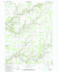
1959 Map of San Jacinto
USGS Topo · Published 1994About this map
Jefferson Proving Ground dominates the landscape of this southern Indiana region, marking a significant military footprint across the intersection of Jennings, Ripley, and Jefferson counties. Established as a U S Military Reservation, the area is defined by an extensive network of specialized transit routes, including Recovery Road, Military Reservation Road, and Eye Road. These pathways cut across the natural drainage systems of Graham Creek and Big Lancaster Creek, which meander through the central and southern portions of the survey.
Find a feature on this map
35 named features on this map. Tap any name to fly to it.
Don’t see what you’re looking for? This feature index may not catch every label — zoom into the map to look around manually.
Map Details
Editions of this 1959 San Jacinto Map
4 editions found

Other maps of this area

1942 · Columbus
USGS Topo · 1:125,000

1946 · Versailles
USGS Topo · 1:24,000

1953 · Cincinnati
USGS Topo · 1:250,000

1956 · Volga
USGS Topo · 1:24,000

1956 · Clifty Falls
USGS Topo · 1:24,000

1956 · Canaan
USGS Topo · 1:24,000

1956 · Louisville
USGS Topo · 1:250,000

1957 · Cincinnati
USGS Topo · 1:250,000

1957 · Butlerville
USGS Topo · 1:24,000

1959 · Holton
USGS Topo · 1:24,000