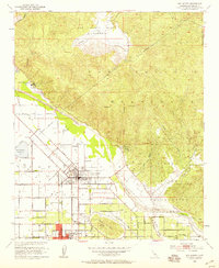
1953 Map of San Jacinto
USGS Topo · Published 1959About this map
San Jacinto and Hemet anchor this mid-century portrait of the San Jacinto Valley, where the grid of city streets meets the rising slopes of the San Jacinto Mountains. The era's complex water management infrastructure is prominent, featuring the Colorado River Aqueduct skirting the base of the mountains and the San Jacinto Reservoir to the west. Local industry and transit are defined by the Atchison Topeka and Santa Fe railroad line terminate near the heart of town, while the surrounding landscape is marked by natural thermal features like Soboba Hot Springs and Gilman Hot Springs. To the east, the Soboba Indian Reservation occupies the rugged foothills, split by the winding course of the San Jacinto River. Rural education and community life are reflected in the presence of the Union High Sch and several cemeteries, providing a detailed record of the area's development before late-20th-century expansion.
Find a feature on this map
59 named features on this map. Tap any name to fly to it.
Don’t see what you’re looking for? This feature index may not catch every label — zoom into the map to look around manually.
Map Details
Editions of this 1953 San Jacinto Map
4 editions found
Other maps of this area

1901 · Southern California Sheet No. 1
USGS Topo · 1:250,000

1901 · San Jacinto
USGS Topo · 1:125,000

1901 · Elsinore
USGS Topo · 1:125,000

1904 · Southern California Sheet No. 1
USGS Topo · 1:250,000

1942 · Banning
USGS Topo · 1:62,500

1942 · Hemet
USGS Topo · 1:62,500

1942 · Murrieta
USGS Topo · 1:62,500

1942 · Perris
USGS Topo · 1:62,500

1943 · Perris
USGS Topo · 1:62,500

1943 · Hemet
USGS Topo · 1:62,500