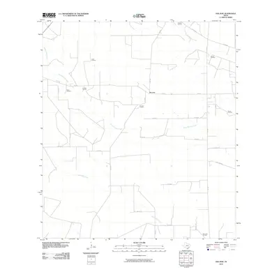
2010 Map of San Jose
USGS Topo · Published 2010About this map
San Jose serves as the focal point for this rural South Texas landscape, where a dense network of family-named cemeteries reflects a deep history of land ownership and ranching heritage. The distribution of sites like Casas Cemetery, Bazan Cemetery, and Ramirez Cemetery indicates a settlement pattern of independent family plots common in Duval County. The terrain is defined by the intermittent drainage of Santa Gertrudis Creek, Jaboncillos Creek, and Piedras Pintas Creek, which carve low-lying paths through the brush country. These waterways, alongside local routes such as FM 2295 and FM 1329, connect the various ranching outposts and burial grounds that anchor the local community. The presence of numerous designated cemeteries, including Santo Nino Cemetery and La Moda Cemetery, provides essential data for genealogists tracing South Texas families in the early 21st century.
Find a feature on this map
29 named features on this map. Tap any name to fly to it.
Don’t see what you’re looking for? This feature index may not catch every label — zoom into the map to look around manually.
Map Details
Editions of this 2010 San Jose Map
This is the sole edition of this map. No revisions or reprints were ever made.
Other maps of this area

1917 · Ben Bolt
USGS Topo · 1:62,500

1921 · Falfurrias
USGS Topo · 1:125,000

1956 · Benavides
USGS Topo · 1:62,500

1956 · Laredo
USGS Topo · 1:250,000

1963 · Ben Bolt NW
USGS Topo · 1:24,000
1963 · Palito Blanco
USGS Topo · 1:24,000
1963 · Seeligson Ranch
USGS Topo · 1:24,000

1968 · Concepcion
USGS Topo · 1:24,000

1968 · Benavides NW
USGS Topo · 1:24,000

1968 · San Jose
USGS Topo · 1:24,000