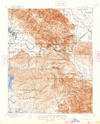
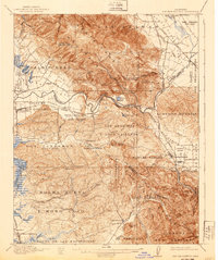
1917 Map of San Juan Bautista
USGS Topo · Published 1947About this map
Mission San Juan Bautista and its surrounding ranchos anchor this survey of the central California corridor where the Santa Cruz Mountains and Gabilan Range meet. The landscape is defined by the winding course of the Pajaro River through the Pajaro Gap, a critical topographic pass that dictated the routes of the Southern Pacific Railroad and early state highways. Early industrial activity is evident at the Sargent Oil Fields and the Cement Works near the San Benito county line, while the coastal lowlands near Watsonville show a dense network of educational and social institutions, including the St Francis Orphan Asylum and several rural schoolhouses like Carlton School. Large Spanish land grant names such as Bolsa Nueva y Moro Cojo and San Justo remain imprinted on the terrain, marking the transition from colonial grazing tracts to the burgeoning agricultural and rail economy of the early twentieth century.
Find a feature on this map
107 named features on this map. Tap any name to fly to it.
Don’t see what you’re looking for? This feature index may not catch every label — zoom into the map to look around manually.
Map Details
Editions of this 1917 San Juan Bautista Map
6 editions found
Other maps of this area

1910 · Salinas
USGS Topo · 1:31,680

1912 · Salinas
USGS Topo · 1:62,500

1912 · Capitola
USGS Topo · 1:62,500

1913 · Monterey
USGS Topo · 1:62,500

1914 · Capitola
USGS Topo · 1:62,500

1915 · San Juan Bautista
USGS Topo · 1:48,000

1916 · New Almaden
USGS Topo · 1:48,000

1917 · Morgan Hill
USGS Topo · 1:62,500

1917 · San Juan Bautista
USGS Topo · 1:62,500

1919 · Hollister
USGS Topo · 1:48,000