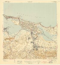
1941 Map of San Juan
USGS Topo · Published 1941About this map
La Fortaleza and the imposing Morro Castle anchor the historic peninsula of San Juan in this 1941 survey, showing the capital just before the massive post-war expansion. The map details a landscape where traditional coastal fortifications meet modern 20th-century infrastructure, including the American Railroad and the primary arteries of Avenida Ponce de Leon and Avenida Fernandez Juncos. To the south and east, the growth of the metropolitan area is visible in the development of Hato Rey and the Barriada Eleanor Roosevelt, contrasting with the more rural terrain around Montes de San Patricio. Significant social and institutional landmarks are documented, from the Universidad de Puerto Rico and Hospital Presbiteriano to specialized sites like the Sanatorio Insular and Manicomio Insular. The coastal geography is finely rendered, highlighting the Laguna del Condado and the wetlands surrounding Laguna San Jose.
Find a feature on this map
83 named features on this map. Tap any name to fly to it.
Don’t see what you’re looking for? This feature index may not catch every label — zoom into the map to look around manually.
Map Details
Editions of this 1941 San Juan Map
2 editions found
Other maps of this area

1940 · Carolina
USGS Topo · 1:30,000

1941 · Bayamon
USGS Topo · 1:30,000

1941 · San Juan
USGS Topo · 1:30,000

1941 · Carolina
USGS Topo · 1:30,000

1946 · Aguas Buenas
USGS Topo · 1:30,000

1946 · Naranjito
USGS Topo · 1:30,000

1946 · Gurabo
USGS Topo · 1:30,000

1947 · Carolina
USGS Topo · 1:30,000

1947 · Aguas Buenas NO
USGS Topo · 1:10,000

1947 · Bayamon
USGS Topo · 1:30,000