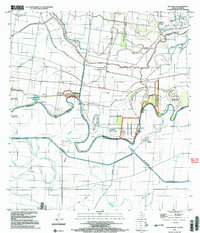
2002 Map of San Juan SE
USGS Topo · Published 2003About this map
The Rio Grande Bravo serpentines through this binational landscape, defining the border between Texas and Tamaulipas. In this river-driven economy, the Donna Main Canal and the Donna Pumping Station illustrate the sophisticated irrigation systems critical to the Lower Rio Grande Valley. The terrain is marked by numerous river bancos, such as Longoria Banco No 39 and Balli Banco No 35, representing former river loops that have become permanent land features.
Find a feature on this map
35 named features on this map. Tap any name to fly to it.
Don’t see what you’re looking for? This feature index may not catch every label — zoom into the map to look around manually.
Map Details
Editions of this 2002 San Juan SE Map
This is the sole edition of this map. No revisions or reprints were ever made.
Other maps of this area

1914 · San Juan
USGS Topo · 1:48,000

1916 · San Juan
USGS Topo · 1:62,500

1949 · Mc Allen
USGS Topo · 1:250,000

1953 · Brownsville
USGS Topo · 1:250,000

1954 · McAllen
USGS Topo · 1:250,000

1956 · Mercedes
USGS Topo · 1:24,000
1956 · Progreso
USGS Topo · 1:24,000

1956 · Brownsville
USGS Topo · 1:250,000

1956 · Port Isabel
USGS Topo · 1:250,000

1957 · Mc Allen
USGS Topo · 1:250,000