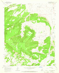
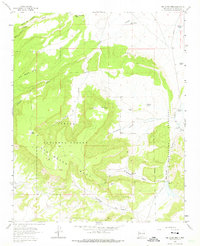
1963 Map of San Lucas Dam
USGS Topo · Published 1965About this map
San Mateo Mesa dominates this 1963 landscape, a high-desert terrain marked by complex water management and high-elevation plateaus. The topography is defined by significant features like Banco Isidro and Jesus Mesa, which rise out of the Cibola National Forest. For local history, the infrastructure of the high desert is visible through numerous livestock and irrigation points, including the San Lucas Dam and the Leopoldo Diversion Dam on the eastern edge. A Grant Boundary cuts through the southeastern corner, while the presence of the Cliffside Mine and other unnamed Mine sites suggest the area's geological and extractive interests during the mid-20th century. A network of Jeep Trails provides the primary access through canyons like Mulatto Canyon and La Polvadera Canyon, connecting isolated water tanks such as Jose Gabriel Tank and Michael Tank.
Find a feature on this map
31 named features on this map. Tap any name to fly to it.
Don’t see what you’re looking for? This feature index may not catch every label — zoom into the map to look around manually.
Map Details
Editions of this 1963 San Lucas Dam Map
3 editions found

Other maps of this area

1883 · Mt. Taylor
USGS Topo · 1:250,000

1886 · Mt. Taylor
USGS Topo · 1:250,000

1892 · Mt. Taylor
USGS Topo · 1:250,000

1899 · Mt. Taylor
USGS Topo · 1:250,000
1957 · Ambrosia Lake
USGS Topo · 1:24,000
1957 · Dos Lomas
USGS Topo · 1:24,000

1958 · Albuquerque
USGS Topo · 1:250,000

1961 · El Dado
USGS Topo · 1:24,000

1961 · Piedra De La Aguila
USGS Topo · 1:24,000

1962 · Albuquerque
USGS Topo · 1:250,000