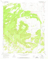
1963 Map of San Lucas Dam
USGS Topo · Published 1975About this map
San Mateo Mesa dominates this high-altitude landscape within the Cibola National Forest, revealing a network of canyons and water-management features used for ranching in McKinley County. The map documents numerous cattle tanks and wells, such as Jose Gabriel Tank, Michael Tank, and the Polvadera Well, which provided essential water sources in the arid terrain. The presence of the Cliffside Mine in the southwest corner and another unnamed Mine to the north points to the mineral extraction history of the region.
Find a feature on this map
32 named features on this map. Tap any name to fly to it.
Don’t see what you’re looking for? This feature index may not catch every label — zoom into the map to look around manually.
Map Details
Editions of this 1963 San Lucas Dam Map
3 editions found
Other maps of this area

1883 · Mt. Taylor
USGS Topo · 1:250,000

1886 · Mt. Taylor
USGS Topo · 1:250,000

1892 · Mt. Taylor
USGS Topo · 1:250,000

1899 · Mt. Taylor
USGS Topo · 1:250,000

1957 · Ambrosia Lake
USGS Topo · 1:24,000

1957 · Dos Lomas
USGS Topo · 1:24,000

1958 · Albuquerque
USGS Topo · 1:250,000

1961 · El Dado
USGS Topo · 1:24,000

1961 · Piedra De La Aguila
USGS Topo · 1:24,000

1962 · Albuquerque
USGS Topo · 1:250,000